
Hurricane Michael Makes Landfall on Florida’s Panhandle as a Terrifying Category 4 Storm
Hurricane Michael Highlights
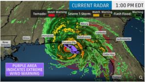 Hurricane Michael has made landfall near Mexico Beach with sustained winds of 155 mph
- Michael made landfall as the strongest hurricane to hit the Panhandle in recorded history with its winds and storm surge wreaking havoc along the shore
- The powerful category 4 storm is moving northward at 14 mph, and hurricane force winds will extend well inland across portions of the Panhandle, southern Georgia, and southeast Alabama
- Tropical storm conditions will likely affect portions of northeast Florida through North Carolina
- Life threatening storm surges up to 13 feet high are expected for the Florida Panhandle through southern Alabama and Georgia
Hurricane Michael, a frighteningly powerful category 4 storm, made landfall just before 1:00 p.m. on Mexico Beach in the Florida Panhandle according to the National Hurricane Center. The storm had maximum sustained winds of 155 miles per hour. The NHC said the storm was “potentially catastrophic”, and officials in Florida are prepared for widespread devastation.
“Hurricane Michael is forecast to be the most destructive storm to hit the Florida Panhandle in decades”, Florida Governor Rick Scott said. Michael is the strongest storm to hit the U.S. since 1969, and the third most powerful on record to make landfall in the U.S. The governor tweeted this morning that it is too late to evacuate and urged people who didn’t leave to find shelter immediately.
Michael is forecast to bring heavy rains of up to 12 inches, and storm surges of up to 13 feet high are expected for the Florida Panhandle, southern Alabama, and Georgia.
Potential for Widespread Power Outages
Forecasters are predicting that most customers will lose power just inland from Mexico Beach to southwest Georgia, with major tree damage and structural damage along the path of Michael. These power outages may last over a week in some of these areas. Widespread power outages may extend into parts of Georgia, Alabama, South Carolina, and southeast North Carolina.
Cycle Titli Expected to Make Landfall in Eastern India
Cyclone Titli Highlights
 The India Meteorological Department (IMD) has classified cyclone Titli as a very sever cyclonic storm with very high winds speed
- Wind speed at the time of landfall is predicted in the range of 145-165 km per hour
- Landfall of the storm is likely between 6-9 am on Thursday between Gopalpur (Odisha) and Kalingapatnam (Andhra Pradesh)
- Tidal storm surges of one meter are expected
Projected Path
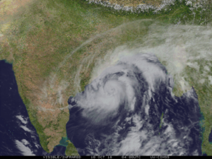
Very severe Cyclone Titli is likely to intensify further over the next 12 hours. Wind speed at the time of landfall will be around 140 to 150 km per hour with gusts up to 165 km per hour in south coastal Odisha and 70 to 80 km per hour in north coastal Odisha. The stormy winds will continue to lash the area starting at midnight tonight till tomorrow afternoon. It is likely to intensify further and move in a north/northwesterly direction.
![]()
A storm surge warning has been issued for the districts of Ganjam, Puri and Khurda. The IMD has issued an evacuation of the low lying areas of the coastal belt including the districts of Ganjam, Puri, Khurda, Kendrapara and Jagtsinghpur.
The India Meteorological Department (IMD) has issued a red alert and predicted heavy to very heavy rainfall over Gajapati, Ganjam, Puri, Jagatsinghpur and Kendrapara districts over the next 24 hours. An orange warning and heavy to very heavy rainfall alert has been issued for Khurda, Nayagarh, Cuttack, Jajpur, Dhenkanal, Bhadrak, and Balasore districts until the morning of October 11.